The Data Difference: Advances in Marine Weather Forecasting
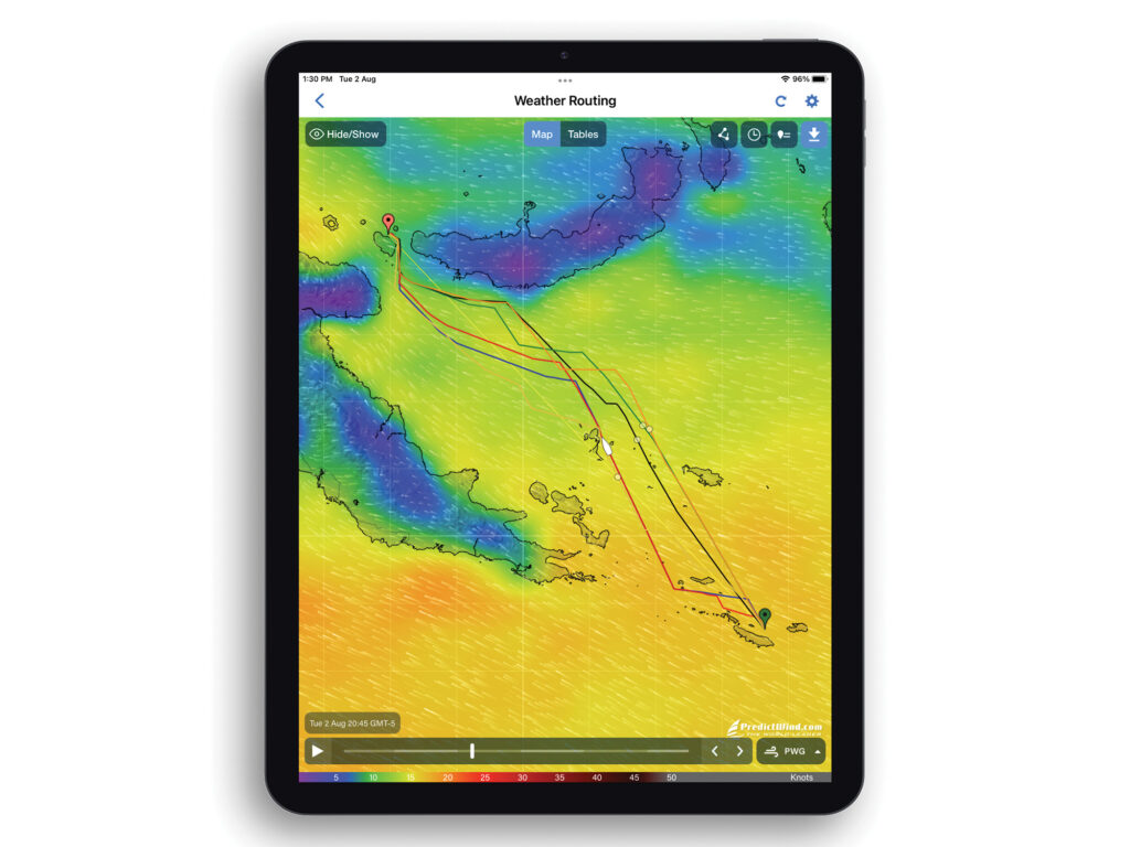 PredictWind weather routing calculates routes to avoid rough seas, strong winds, land and shallow water to ensure a safe and efficient passage. Every route is calculated using the highest-resolution forecast data from six models, giving cruisers more confidence in the weather.
Courtesy PredictWind
PredictWind weather routing calculates routes to avoid rough seas, strong winds, land and shallow water to ensure a safe and efficient passage. Every route is calculated using the highest-resolution forecast data from six models, giving cruisers more confidence in the weather.
Courtesy PredictWind
More than 1 million cruising boaters are now using PredictWind, a weather-forecasting service created in 2010 by competitive sailor Jon Bilger. He founded the company after serving as weather manager for teams who won the America’s Cup in 2003 and 2007, when he realized that the higher-end technology could be a boon to the cruising public.
“It’s been quite a journey,” Bilger told Cruising World in early March, adding that as the community of cruisers continues to evolve with different styles of boats, PredictWind has been evolving right along with it. Sailors are still the company’s biggest client base, and those who make the shift to powerboats can now also use PredictWind to help with routing that optimizes fuel efficiency.
That kind of advancement in forecasting capabilities is in great part due to technology. What’s possible in terms of forecasting today is far different—and much more detailed—than when Bilger founded PredictWind 14 years ago.
It’s a timespan that might as well be an eon when it comes to technological advancements. When PredictWind was created, the Blackberry still dominated the handheld marketplace. The iPad was brand-new. So was Instagram. Forget about today’s 4K screens; manufacturers were still trying to get people to understand the difference that a 3D screen could make when watching hot new movies like Avatar. Uber was just one year old. Lyft didn’t even exist.
It was also in 2010 that Google started to personalize users’ search results. Machine learning began to analyze and predict all kinds of things, as wide-ranging as voter behavior and power-grid spikes. As CNN reported: “In 2010, artificial intelligence was more likely to pop up in dystopian science-fiction movies than in everyday life. And it certainly wasn’t something people worried might take over their jobs in the near future.”
Oh, how times have changed—in some ways, for the better. PredictWind is embracing AI to create products that help with weather forecasting in ways that seemed unimaginable until recently.
Just one example is the company’s newest service, PredictCurrent, which Bilger says is a world first.
“This is very, very simple,” he explains. “You put your location in. You say, ‘This is the current I want to know about.’ And then, boom, you get a graph. We give you windspeed and wind direction as well, and you get current speed and direction, and we give you a map, so you can actually see, hour by hour, how the current is changing over the whole area. It’s amazing to see that sort of detail on your iPad or your laptop.”
PredictCurrent covers tidal currents for 90 percent of the world’s coastlines, he says. The level of detail and accuracy is best within 90 kilometers (about 55 miles) of the coast, but there is also information about currents as far as 600 kilometers (nearly 375 miles) offshore.
“It’s amazing. You can see how the eddies and currents are changing,” Bilger says. “Compute power for the whole world is enormous. The storage capacity is there. It’s a pretty cool thing.”
Another new product from PredictWind is called Over the Horizon AIS. Typically, Bilger says, a cruising boater can receive an AIS signal within just a few miles of an oncoming hazard such as a container ship. Over the Horizon AIS compiles data from the Automatic Identification System worldwide—“We pay a lot of money to get that information,” he says—and customizes it for use by individual cruising boats through the PredictWind DataHub smart device.
“This is very, very simple. You put your location in. You say, ‘This is the current I want to know about.’ And then, boom, you get a graph.”
“It can download the data every minute with a Starlink connection, and it shows vessels out to about 300 nautical miles,” Bilger says. “If you have a container ship barreling at you, maybe you have about eight minutes to take evasive action. We can give you something more like eight hours.”
The capabilities that Starlink offers are hugely important for some of these newer features, Bilger says, but he tempers his enthusiasm for the satellite service with a caution for offshore cruisers.
“We genuinely are huge fans of Starlink. It means that people can get weather forecasting offshore, and get it a lot easier,” he says—adding a big but. “If you go offshore, you need to have a satellite phone, an Iridium Go. If the power on your boat goes down, Starlink requires AC power. If you have a problem with your inverter, you have no communications. You really should have something with a battery backup on it.”
With that said, Bilger is gung-ho about all the information cruisers can now access on a regular basis thanks to Starlink, instead of having only occasional access to downloads. The amount of data coursing through PredictWind’s DataHub, coupled with artificial-intelligence analysis, can create things such as polars for a specific boat.
These “AI polars,” as Bilger calls them, represent the performance of a boat in different wind and wave conditions—information that can be critical for weather routing.
“Normally, you select from a predefined list of polars for all the boat types, and then there’s a velocity-prediction program that shows the ideal speed of your boat in perfect conditions,” he says. “But that’s not reality. That’s not how you sail a boat. With the DataHub, it’s reporting your windspeed, your direction, and it averages that data. It sends it back to our service and compares it. Over time, it will learn how you sail the boat, and you’ll even have a different set of polars for daytime and nighttime.”
Today’s level of artificial intelligence is required to make these types of services possible, he adds.
“Our service is doing billions of calculations for six of the top-level models, and boom, you get the comparison,” he says. “It’s way easier and very powerful to have. You really have no excuse to get caught out in bad weather.”
Similar use of technology allowed PredictWind to launch a product last year that helps cruisers better understand the wave state that they are likely to encounter.
“Generally, all weather services give you the primary wave state,” Bilger says. “We have modeled monohulls, catamarans, trimarans, sailboats and powerboats, and every possible wave state. We know exactly how the boat’s going to perform based on length, beam, displacement.”
This level of detail makes it easier for boaters to make better-informed choices, he says.
“The real kicker is that we can display how much the boat’s going to roll, and whether it’s going to be dangerous to be on deck,” he says. “The other one is vertical acceleration. If you’re going over a big sea state, you’re going to be going up and down a lot, which affects seasickness. And we can talk about slamming. That’s a big one as well. When you do your weather route, you can see all of that during a trip. If you use a departure-planning tool, you can know which day to leave in terms of the degree of roll you’re going to experience. No one else is doing that, as far as we know.”
All of it adds up to more boaters feeling safer and more comfortable out on the water, Bilger says.
“We get emails from families who say, ‘Thank you for keeping us safe all around the world,’” he says. “It’s really cool. It’s why we’re here.”
The post The Data Difference: Advances in Marine Weather Forecasting appeared first on Cruising World.